The Little River Turnpike and George Gilpin’s Vision for Virginia’s Future
From Alexandria to the Blue Ridge: Building the South’s First Successful Toll Road
On July 9, 1795, the Virginia General Assembly chartered the Little River Turnpike Company to construct a toll road from Alexandria westward to Aldie, Virginia. Over the next decade, this ambitious project gave rise to the first successful turnpike in the American South, reducing travel times, spurring trade, and transforming the movement of agricultural goods between the Shenandoah Valley and Alexandria’s bustling port.
Construction began in 1803, and by around 1808, the road extended beyond Aldie to the foothills of the Blue Ridge Mountains. Ultimately stretching over 34 miles, the road followed what we now know as Duke Street in Alexandria and continued west along the route of today’s Little River Turnpike (Route 236). Farmers used the turnpike to bring grain, flour, and livestock to market, while tolls helped maintain the crushed stone surface—an innovation at the time.
Among the project’s key contributors was George Gilpin, a Revolutionary War officer and Alexandria’s leading surveyor and public works visionary. Gilpin helped survey the road’s path and guided its development. Though he died in 1813 and was buried in an unmarked grave, recent ground-penetrating radar research has identified his likely burial site in the Christ Church Episcopal Cemetery. His pivotal yet often-overlooked contributions to Alexandria’s infrastructure—including the Little River Turnpike, city wharves, and the 1798 map of Alexandria—cement his legacy as a foundational figure in shaping the region’s economic and physical landscape.
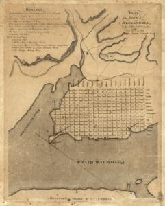
George Gilpin’s 1798 map of Alexandria, showing the original street grid and waterfront. Created to support city planning, it highlights Gilpin’s role as surveyor and civic leader.